Natural hazards for nature-based carbon
Carbon projects are exposed to a range of natural hazards, from fire and drought, to sea level rise, pests and diseases. BeZero combines near real-time monitoring and long-term satellite time series of disturbance mechanisms and impacts, to assess risks to carbon efficacy for all nature based projects.
These assessments inform our view of non-permanence risk, as well as over-crediting and leakage risks associated with accurate reporting of disturbance events. Our opinion on the efficacy of carbon credits depends on how reliably past emissions are accounted for, and on the project mitigations in place to counter future risk through buffer pools or interventions on the ground.
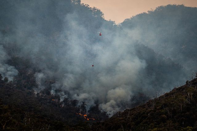
Carbon emissions resulting from natural hazards vary with the area affected and the severity of ecosystem impacts. For instance, drought can affect large areas but generally results in modest carbon emissions per unit area, whereas fire impacts are more concentrated and severe. Interactions between different natural hazards, like drought and fire, are often complex, modified by human land use, and single events can manifest as both short-term (direct) and long-term (committed) emissions.
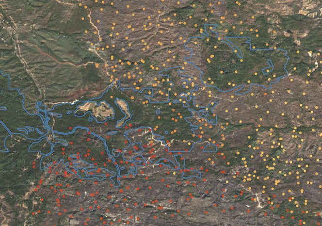
Active wildfires detected by thermal instruments at satellite overpass (yellow to red dots) are overlaid with optical satellite imagery (background image) to provide rapid assessment of ecosystem impacts. Project boundaries are shown in blue.
We source information on fire, climate, and sea level rise from space agencies, national research institutes, and academic labs. For example, our assessment of drought risk begins with a summary of climatological conditions across the project area and surrounding landscapes. This encompasses both long-term averages mapped at c. 1 km spatial resolution, and times-series of intra- and inter-annual variation mapped at c. 10 km resolution. Using long-term records of precipitation and temperature from the ECMWF together with soils data from ISRIC, we construct drought indices to understand how drought-stress on vegetation and soils is changing over time. These indices stretch back to the 1980s (when data from weather satellites became more reliable) and we update them annually.
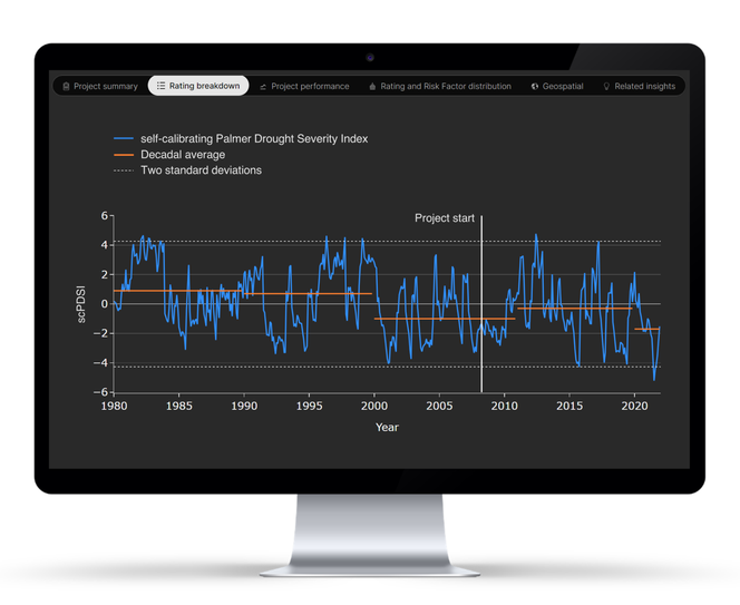
Persistent or severe drought conditions can cause tree mortality, and may increase the risk of further carbon emissions from wildfires, pests or diseases. Our risk assessments include time-series analysis of drought indices such as the Standard Precipitation Index (SPI) and the self-calibrating Palmer Drought Severity Index (scPDSI). Interactive drought charts are an upcoming feature on the BeZero Carbon Markets platform.
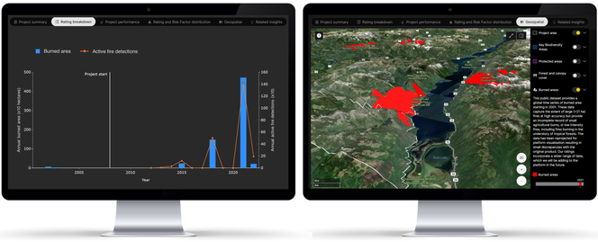
For some ecosystems, we observe a close relationship between drought and fire. We assess the extent of fire disturbance using a record of satellite-derived burned areas from NASA spanning more than two decades. Active fire detections, or ‘hot pixels’, observed by the latest generation of thermal instruments, provide near-real time context on carbon combustion and complementary detections of fires as small as 1 ha, including those in the forest understory.
Damage from drought and wildfires can also increase the vulnerability of vegetation to pests and diseases (and vice versa), especially in contiguous areas with low species diversity, as is common for managed forests in the IFM and ARR subsectors. Our Ratings team reviews literature on the spatial distribution of common pests and diseases relevant to planted species, and we take a holistic view of these risks given planting patterns and project activities.
Long-term records of satellite imagery provide context on emerging non-permanence risk. For example in the western United States and Canada, rising temperatures and enhanced drought conditions have resulted in increasing fire activity inside and outside carbon projects over time.
Carbon projects commit to reducing or removing emissions for a given period of time. For nature-based projects, this commitment period can span decades. We are therefore expanding our geospatial risk analysis to incorporate future projections of natural hazards using an ensemble of climate models and warming scenarios.
For projects in coastal ecosystems, such as mangroves, we assess non-permanence risks associated with projected sea level rise using data from NASA and the IPCC 6th Assessment Report. Exposure to risk is considered alongside the project’s commitment period, buffer contributions, and environmental factors affecting the capacity for ecosystem resilience, such as land use and sediment supply. We are similarly incorporating future climate projections into our drought models, with rollout in our ratings and on our platform expected later this year.
BeZero scientists are continuously expanding the scope and depth of our natural hazards analysis. We recently announced partnerships with leading research institutions in Brazil, to monitor drought and fire impacts on the ground in the Amazon rainforest. This week, we announced further partnerships with the Royal Netherlands Meteorological Institute (KNMI) and Dresden University of Technology (TU-Dresden), to work on a European Space Agency project harnessing satellite capabilities for tracking carbon emissions from wildfires.
BeZero’s insights into natural hazards and associated risk factors are part of our ratings process for all nature-based projects. These analytics are being rolled out on the BeZero Carbon Markets platform, enabling direct exploration of spatial datasets and interactive charts, in the context of our full risk-based analysis of carbon credit quality.
To learn more about our geospatial research and platform tools, or to request a demo of the BeZero Carbon Markets platform, reach out to commercial@bezerocarbon.com