Beyond binaries: forest change in drylands
Carbon credits have historically been treated as binaries: either they offset one tonne of emissions, or not. BeZero’s carbon ratings address the reality that quality and risk exist on a spectrum - some carbon credits are more likely to deliver on their climate commitment than others.
Reporting on forest loss assumes a similar binary: forest or not forest. In the heart of the Amazon, the Congo basin, or among towering dipterocarps in Borneo, this dichotomy makes sense. Rainforest canopies are dense and persist across seasons. Clearcuts or land cover conversion can be reliably detected, and usefully classified as forest loss using widely available monitoring tools.
But just as credits vary in quality, forests vary in density. In drylands, forest canopies are open and seasonal. For credits issued from these locations, assessing quality requires that we monitor forests across a wide spectrum of tree cover. This is also important for wet forests, where changes in canopy density can indicate carbon emissions from degradation. For dry forests though, their recognition as forests at all hinges on accurate monitoring of tree cover, and even of individual trees.
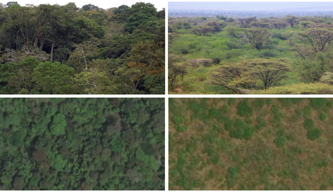
Examples of wet evergreen forest (left) and dry seasonal forest (right), as viewed from the ground (upper) and from satellite (lower). Widely available global forest monitoring tools tend to perform well in wet forests and poorly in dry forests, because their spatial and temporal resolutions cannot capture trees at low canopy density nor the seasonality of their leaves.
At BeZero, we use regional and global monitoring tools to estimate forest extent and change. Through industry partnerships, our analysts have access to cutting-edge models built using airborne and space borne LiDAR, synthetic-aperture radar and multispectral measurements. Nonetheless, at the scale of individual carbon projects, and especially for open and seasonal vegetation, it is important to understand the limitations of these models. Where accuracy is low, we are developing solutions in house, bespoke to the project context.
From these validations and our team’s decades of experience surveying field sites across eastern and southern Africa, and in the Brazilian Cerrado, it is clear that dry forests pose particular challenges. Our research and development is targeting these ecosystems, where large-scale forest monitoring tools underestimate tree cover, or else cannot reliably detect changes over time.
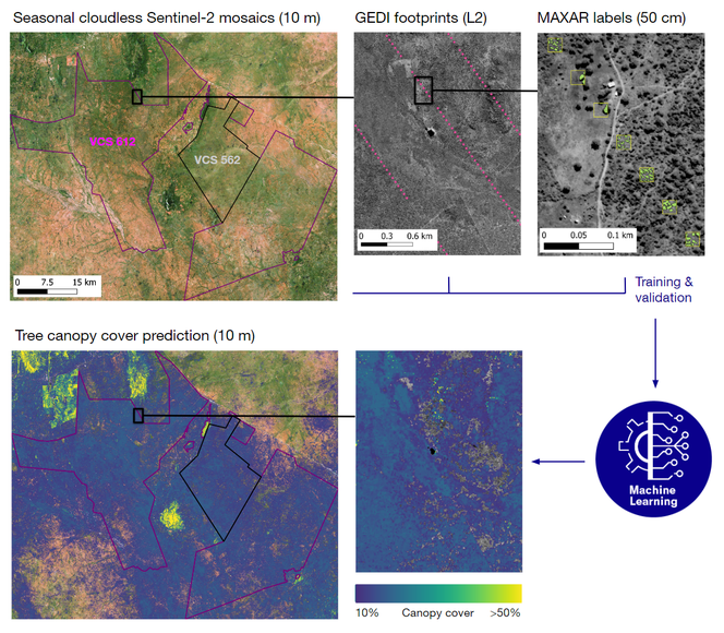
BeZero’s tree canopy mapping, illustrated for the Kasigau Corridor REDD Projects in southern Kenya. Our machine learning models combine in-house Sentinel-2 cloudless mosaics with LiDAR data from the Global Ecosystem Dynamics Investigation (GEDI) and tree crowns labelled on high-resolution commercial imagery. For these landscapes, global forest change maps detect little forest, whereas we identify extensive open forest cover at a 10% canopy threshold.
Our analysis begins with characterising vegetation phenology, to understand the times of year when tree crowns are most distinct. Sentinel-2 provides over seventy multispectral images per year for all global land areas at c. 10-m spatial resolution, but cloud cover can limit data availability during growing seasons. The algorithms we are developing optimise for cloud-free imagery, while tuned to the specific phenology of the project’s forests. These seasonal mosaics enable separation of different land cover and vegetation fractions based on their unique spectral signatures.
Information on tree height is derived from spaceborne LiDAR, and overlaid with very high-resolution commercial satellite data (e.g. MAXAR, 50 cm) in samples across the project landscape. Using these data, we label individual tree crowns with high spatial precision. Our machine learning models use the labels for training and quality assessment, and extrapolate to the wider landscape using the seasonal mosaics from Sentinel-2.
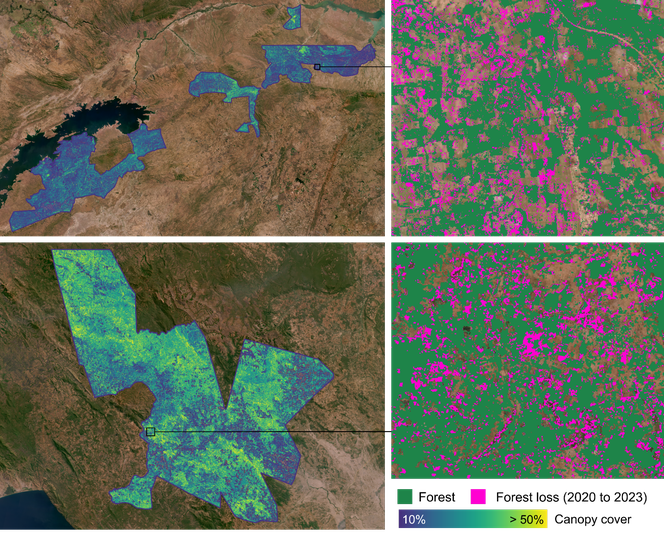
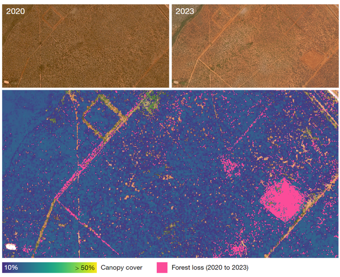
Change detection illustrated for the Kariba REDD+ Project in Zimbabwe (upper) and the Ntakata Mountains REDD Project in Tanzania (lower). BeZero’s in-house models estimate tree canopy distributions (left), which we can threshold to align with a project’s forest definition and loss reporting (right). For these landscapes, global forest change maps have low accuracy and cannot be relied upon for change detection. Basemaps are from PlanetScope.
The UN Food and Agriculture Organisation defines forest as having tree canopy cover of at least 10%, with trees defined as being at least 5-m tall. Different carbon projects and jurisdictions have their own definitions. In Kenya for example, the national definition is 15% canopy cover of trees at least 2-m tall, whereas in neighbouring Uganda the thresholds are 30% and 4 m. Most carbon projects adhere to the 10% canopy definition, but under new jurisdictional accounting frameworks they may need to align with national reporting.
In high canopy cover, wet evergreen forests, the differences in forest definition have little impact. In seasonal dry forests, lower canopy densities necessitate the kinds of locally-calibrated, multi-sensor models developed at BeZero, to fairly assess project-level and country-reported changes in forest extent and carbon stocks.
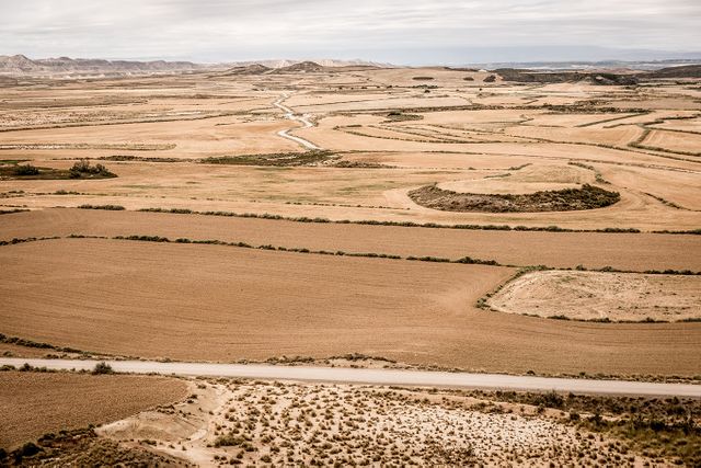
Upper: satellite views (PlanetScope) of seasonal dry forest in southern Kenya, during the dry season. Lower: BeZero’s models detect large areas of clear cut and tree loss emanating from the expansion of unpaved road networks.
Every forest ecosystem has unique characteristics. At BeZero, we are developing the targeted tools required to monitor forest dynamics in the most challenging of settings. The examples shown here are illustrative and we are working to refine our procedures before rollout across our rated projects.
Meanwhile, we are advancing our regional and global monitoring capabilities through partnerships, leveraging collaborative efforts to achieve a comprehensive understanding of forest carbon, across all forest types, and laying the groundwork for further development.
BeZero’s commitment to advancing methodologies through technology, fieldwork, partnerships and outreach empowers robust risk analytics and informed decision-making in all sectors of the voluntary carbon market.