LiDAR and Forest Carbon
Here are some key takeaways
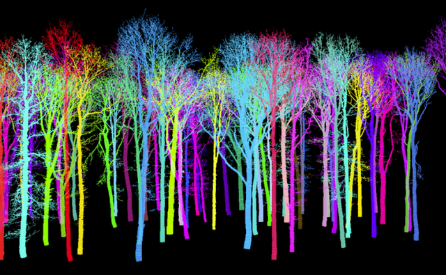
LiDAR instruments can be mounted on terrestrial, airborne, or spaceborne platforms, providing estimations of forest structure with varying coverage, resolution and accuracy.
Forest structure, measured in the field or remotely using LiDAR, synthetic-aperture radar, or photogrammetry, is a crucial component of carbon stock estimation. Each technique has limitations, so robust, scalable monitoring depends on a fusion of data types combined with field surveys on species composition and structural ground-truth.
When rating carbon credits, other considerations such as financial additionality, baselines, leakage, and non-permanence remain vital, and often outweigh the risks posed by errors or uncertainties in the reported carbon stock.
BeZero assesses carbon stocks using state-of-the-art commercial datasets from Planet and Kayrros, public datasets from space agencies and academic labs, and in-house development of novel monitoring products and extensive ground-truth.
Contents
Forests are an important climate solution
The challenge of measuring forest carbon
Types of LiDAR and forest monitoring applications
Limitations of remote measurement of carbon stocks
How BeZero assesses forest carbon stocks
What moves the needle for credit risk?
Conclusion