Taking stock of forest carbon
Carbon market participants require independent assessments of carbon stocks to inform over-crediting risk, leakage impacts (activity displacement) and reversal events. These assessments need to be dynamic, and consider the direct and committed emissions from logging, fire and drought, as well as outright deforestation.
Carbon mapping is an evolving science. Forest inventories provide essential measurements of above and below ground carbon stocks, but these are limited in coverage and the available ground data are from diverse sources with a wide range of sampling designs. Remote sensing technologies, deployed on aircrafts and satellites, enable larger-scale, standardised assessment, but have sensor-specific limitations. Therefore, carbon maps often combine ecosystem properties that can be measured remotely from above, including canopy height and cover, with in situ measurements from inventory plots, including species composition and wood density.
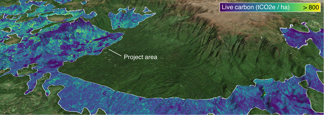
Example of globally-derived carbon estimates, mapped for a carbon project in Ethiopia. Source data from ESA DUE GlobBiomass (above and below ground live carbon). The model combines data from spaceborne LiDAR, synthetic-aperture radar and multispectral imagery, with in situ measurements and auxiliary information on land use and climate.
Tropical ecosystems contain about 40% of global forest carbon. They are dynamic and diverse, and the relationship between forest structure as measured remotely and carbon stocks on the ground varies in space and time. At BeZero, we believe there is no perfect carbon map, and that different data sources and measurement techniques provide unique opportunities to understand carbon stocks at the project level.
BeZero collaborates with a range of academic and commercial partners, to access regional and global carbon maps, and to advance remote sensing technologies. For example, we recently signed partnerships with the Amazon Environmental Research Institute (IPAM), and with the Division of Geoinformatics and Earth Observation at Brazil’s National Institute for Space Research (INPE).
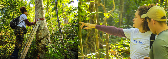
BeZero is working with local partners to support the development of forest inventory plot networks in the Amazon rainforest.
With IPAM, we are supporting Brazilian post-graduates in their carbon research. Through INPE, we are supporting the development of a forest inventory network, including measuring existing field sites and expansion of the plots network into areas of highest uncertainty for projects in the VCM. Measuring plots at different points in time provides insights into carbon dynamics and the impacts of disturbances such as fire and drought. Forest degradation is especially difficult to monitor remotely, and is frequently omitted from carbon accounting, with associated risk of over-crediting, leakage and non-permanence.
This work feeds into the BeZero Carbon Plots Database, which harmonises ground-measured carbon from research partnerships, private collections, national inventories, international plot networks, academic literature, and other sources. The database currently spans more than 5,000 sites in tropical forests alone, collating millions of stem-level estimations of tree volume and species-specific wood density, linked with scores of allometries, and BeZero’s remote sensing and markets data.
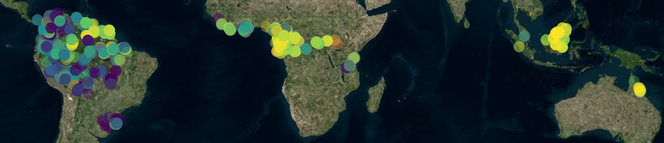
The BeZero Carbon Plots Database is a global reference dataset of forest carbon stocks, aggregating and harmonising field data from a wide range of sources, and linking these with remote sensing and markets data.
We leverage these data and partnerships in three ways. First, to directly assess project-reported carbon stocks, given available field data for a project’s location, forest type and disturbance history. Second, to validate and select the most appropriate satellite-derived carbon maps for landscape-scale monitoring. And third, to identify and address current limitations in the remote estimation of forest carbon.
The most accurate carbon maps are often targeted in scope, and combine extensive field data with airborne remote sensing and satellite observations. For example, the Brazilian National Carbon Map leverages a dense network of airborne LiDAR observations, intersecting with forest inventories and satellite imagery.
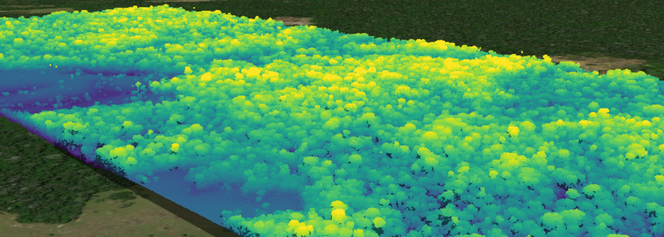
Point cloud of Amazonian forest structure measured using airborne LiDAR (Embrapa Paisagens Sustentáveis). Beneath this canopy, BeZero scientists are working with local partners to monitor carbon dynamics on the ground.
We select the most relevant field and spatial datasets for each carbon project, and establish a range of plausible stock densities and associated uncertainty. Projects provide estimates of carbon stock density in various carbon pools, with larger reported stocks increasing the number of credits that can be issued. Projects reporting estimates outside a credible range are deemed at higher risk of over-crediting in this respect, especially if the project has undertaken insufficient or biased in situ ground measurements.
BeZero’s insights into carbon reporting and associated risk factors are part of our ratings process for all forestry projects. These analytics are being rolled out on the BeZero Carbon Markets platform, enabling direct exploration of spatial datasets and interactive charts, in the context of our full risk-based analysis of carbon credit quality.
Watch BeZero's Dr Camila Silva, Remote Sensing Ecologist and Researcher at IPAM, during her recent field site visit in the state of Acre, Brazil.
To learn more about our geospatial research and platform tools, reach out to commercial@bezerocarbon.com
Learn more about Geospatial and Earth Observation at BeZero.