Mapping the market: BeZero’s global boundaries database
BeZero has built the most complete spatial database of nature-based projects in the voluntary carbon market - over 3,000 projects across 20+ registries.
The database resolves long-standing issues of scattered, inconsistent boundary data that have led to duplication of effort, flawed baselines, and double counting.
By mapping every project, BeZero enables accurate overlap detection, stronger baseline methodologies, and market-wide benchmarking of carbon project risks.
Regularly updated, the database supports developers, standards bodies, investors, and researchers in advancing transparency and quality across the market.
Mapping every project
One year ago, we committed to building the most complete spatial database of nature-based projects in the voluntary carbon market (VCM). This week, we published the results on the BeZero platform.
Everyone needs this, from developers to standards bodies, investors to buyers, governments, ratings agencies, journalists and academics. Until now, the market contended with scattered, inconsistent boundary data, leading to duplication of effort, flawed baselines, and double counting.
There are over 3,000 nature-based projects in the VCM, distributed across 20+ registries. We investigated every one - checking their boundaries against project documents, digitising where possible, and attaching quality labels and other metadata, such as registry status (34% of projects are registered and active, 42% are in earlier stages of development, and 24% are completed, inactive, rejected or withdrawn). The results are stored in a single harmonised spatial database.
We found perfectly digitised field boundaries, hand drawn pencil sketches, and everything in between. Around 600 projects required manual digitisation or correction - a reflection of why nothing comparable to BeZero’s boundaries database has existed before.
BeZero now maintains this system, adding new projects as they enter registry pipelines and monitoring for changes. The flow of new information is increasingly clean and standardised - testament to the market’s growing data maturity.
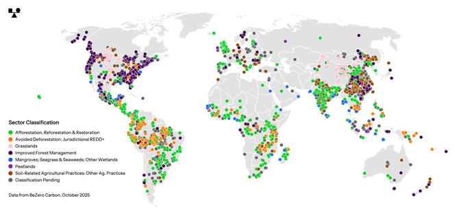
Figure 1. Global distribution of nature-based projects in the voluntary carbon market. Over 80% have a digitised spatial boundary on the BeZero database, represented here as project centroids due to scale.
Strengthening the market
Any rigorous analysis of nature-based carbon projects has to consider where they are. With reliable digital boundary data, that analysis becomes far easier. But why go to the effort of mapping every project, not just the ones most relevant to our customers? Three reasons: double counting, baselines, and benchmarks.
No double counting
When one project overlaps with another, their credits could be double counted. The only way to detect and prevent that is to have visibility of every project’s spatial boundary in one place.
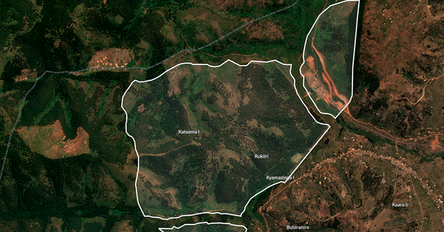
We find that a notable share (up to 10%) of projects overlap in some non-trivial way. In one example, BeZero’s database revealed an overlap unknown to the developers or the standards body; the issue was resolved swiftly, with one project withdrawn. This is exactly the kind of data-driven transparency the market needs — and why we invite developers, standards bodies and governments to use the data.
Better baselines
Methodologies for baseline setting are advancing, from blocky reference regions to statistical pixel matching and jurisdictional risk maps. All approaches, old and new, rely on understanding landscapes not under carbon finance; a baseline estimates what would have happened without project intervention. If those reference landscapes include other carbon projects, the baseline could be compromised.
BeZero’s dynamic baselines incorporate the boundaries database to avoid these blind spots. We encourage developers and standards bodies to do the same.
Market-wide benchmarks
BeZero’s eight-point carbon rating scale (AAA-D) lets market participants understand credit quality, both case-by-case and in comparison to other ratings. The boundaries database takes this a step further, allowing us to benchmark individual aspects of spatial risk against all projects in the market, or a particular subset of those.
Where does fire risk sit in the distribution of all IFM projects in North America, for example? Or biomass estimates for Amazonian REDD, or sea level rise for Mangrove projects globally? The boundaries database makes it possible to answer these kinds of questions.
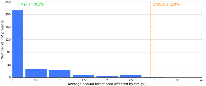
Figure 2. Benchmarking fire risk for Improved Forest Management (IFM) projects across North America. Plot shows the annual percentage of forests affected by fire (2001–2023) in reference landscapes surrounding the projects. Fire risk for CAR1382 (Cohasset 2019) was especially high, with an estimated fire return period of 25-50 years and no fires in at least the last 20; in 2024, 96% of the project area burned.
Taking the market’s temperature
With a spatially complete view, we can take the temperature of the whole market - literally.
Last year, the mean annual temperature across all project boundaries was 17.5 °C (ERA5-Land), ranging from -4.5 °C for the Xinjiang Burqin Improved Grassland Management Project in China, to 30.5 °C for the Tamba 20000 forest restoration project under development Senegal. By 2050, temperatures across the nature-based market are projected to rise by an average of 0.5-1.2 °C relative to 2024, depending on the emissions pathway (NEX-GDDP-CMIP6).
Trees in the VCM weigh in at over 50 billion tonnes of CO2e (Planet Labs), which is equivalent to annual greenhouse gas emissions globally. Between 2000 and 2024, active forestry-sector projects averaged emissions of -0.15 tCO2e per hectare (i.e., net sequestration), while surrounding, non-project landscapes emitted an average of 1.9 tCO2e per hectare over the same period.
The largest project in the world, outside jurisdictional programmes and withdrawn listings, is the Territorio Indígena Originario Campesino REDD Project in Bolivia (3.6 million hectares). The highest, reaching 6,173 m above sea level, is the Tibet Ngari Improved Grassland Management Project. The lowest is TERRRA Santa, an improved agriculture land management project in Israel, with its lowest point at 290 m below sea level.
Spatial overlap with other kinds of protection, for example nature reserves and national parks, sits at 22%, and with Key Biodiversity Areas at 15% (IBAT). A total of 6,485 species listed as Threatened on the IUCN Red List have ranges overlapping with one or more project boundaries, of which 909 species are Critically Endangered.
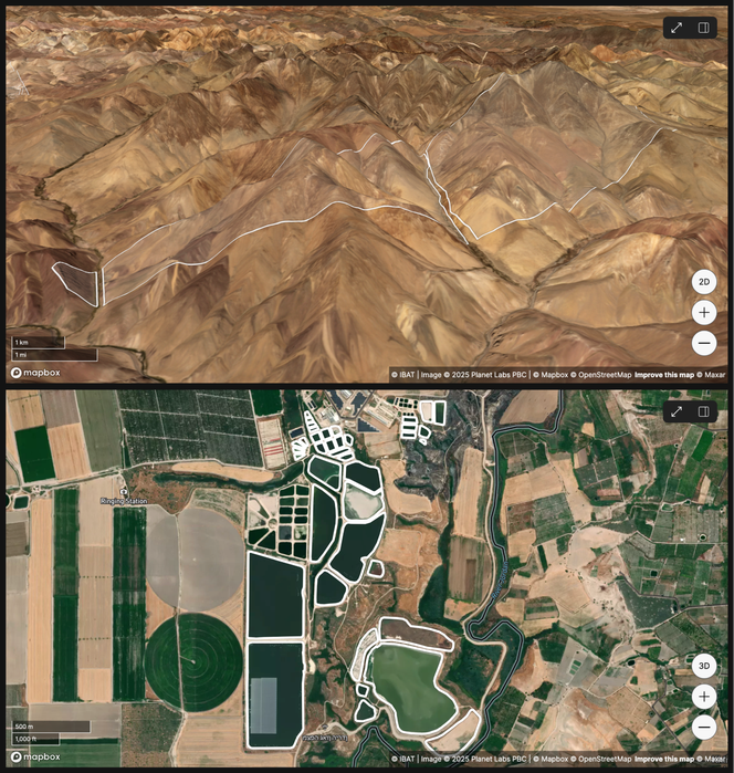
Figure 3. Highs and lows of the VCM. Upper: the highest point is an improved grassland management project in Tibet, peaking here at 6,173 m above sea level (imagery from Planet Labs, Jul-Sep 2025). Lower: the lowest point is along the River Jordan in Israel, where the TERRRA Santa project plans to rewild abandoned fishponds; the ponds shown here are 245-290 m below sea level. As shown on the BeZero Carbon Markets platform.
Accessing the database
BeZero platform customers can explore project boundaries in context - relative to protected areas, road networks, biomass, fires, and other features - and rewind time using high-resolution satellite imagery from Planet Labs, updated every 12 weeks.
The boundaries database can also be made available directly for commercial or non-commercial uses. Already in use by the Tyndall Centre for Climate Change Research, the data are being shared with scientists at the University of Cambridge and the TREES lab at Brazil’s National Institute for Space Research (INPE).
“Access to a unified dataset like this enables us to better understand the market’s role in the global carbon cycle, and its exposure to risks such as wildfires.” - Dr Matthew Jones, Senior Research Fellow at the Tyndall Centre for Climate Change Research, University of East Anglia.
“The BeZero boundary dataset is the most complete record of carbon project locations that I'm aware of. We're keen to use it to strengthen our scientific analyses of carbon project impact." - Dr Tom Swinfield, co-founder of the University of Cambridge’s Centre for Carbon Credits (4C), Chief Science Officer at Canopy PACT, and Technical Advisory Board member at Symbiosis.
“The dataset is critical for assessing carbon project performance, and for evaluating the role of such projects in subnational and national initiatives for forest carbon emission reductions. This will avoid double counting and allow for better policies and investments across the multiple levels of mitigation actions.” - Dr Luiz Aragão, Senior Scientist at INPE and coordinator of the FAPESP Global Climate Change Program.
To request a demo of the BeZero Carbon Markets platform or discuss database access for governance, diligence, monitoring, or academic research, please contact commercial@bezerocarbon.com.