Tracking Indonesia’s fires as El Niño intensifies
El Niño could reach historic strength by year-end. BeZero's satellite monitoring of 32 Indonesian carbon projects reveals elevated fire activity at more than half, with detections in some areas exceeding those seen by this stage of the severe 2015 and 2019 fire seasons.
Fire detections do not quantify carbon losses. Direct emissions and longer-term losses depend on the area burned, severity of disturbance and carbon stocks affected. In peatlands, soil moisture and local hydrology are particularly important. The extent of any carbon losses from the current fires has yet to be established.
A carbon credit's climate benefit depends on what would happen without the project. Many projects aim to protect forests, restore degraded ecosystems and reduce fire risk, including by rewetting peatlands. Current fires highlight the importance of these efforts, both at established projects and those seeking finance through future carbon credit sales.
Observed fires provide new evidence for ongoing ratings assessments. Although fire risk is already factored into BeZero's ratings, analysts continually evaluate carbon impacts, the effectiveness of mitigation measures and how any losses are accounted for.
Record El Niño meets Indonesia’s dry season
El Niño is a major driver of interannual climate variability in Southeast Asia, occurring irregularly every 2–7 years. Warmer surface waters in the central and eastern tropical Pacific alter atmospheric circulation, often reducing rainfall across Indonesia and the wider Maritime Continent.
This year’s event has strengthened rapidly, with daily sea surface temperatures in the Niño 3.4 region exceeding 30 °C for the first time on record (Figure 1). NOAA's latest outlook, issued on 8 October 2026, puts the chance of El Niño reaching historic strength by year-end at 83%, potentially surpassing previous events dating back to 1950.
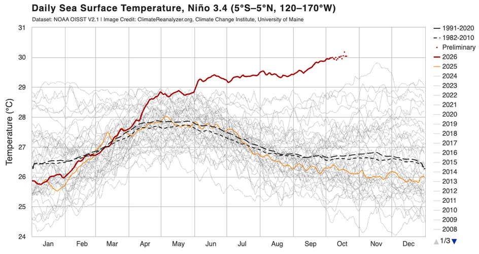
Figure 1. Daily sea surface temperatures in the Niño 3.4 region, showing 2026 in red, 2025 in orange and earlier years in grey. Black lines show the 1991–2020 (solid) and 1982–2010 (dashed) averages. Source: Climate Reanalyzer.
Indonesia is typically among the first regions to experience increased fire activity during El Niño. Its weather agency reported below-normal rainfall across nearly 90% of the country in early October, and issued drought warnings for parts of Sumatra, Java, Kalimantan, Sulawesi and Maluku.
Extensive fires are not typically a natural feature of Indonesia's humid tropical rainforests, and intact, waterlogged peatlands are generally resistant to burning. Drainage and land-use change can substantially increase fire susceptibility, while El Niño-related drought promotes fire spread and hampers containment. Human activities are the main source of ignitions. Climate change can compound these pressures over time through rising temperatures and changes in rainfall patterns.
On drained peatlands, prolonged dry conditions may allow surface fires to ignite underlying peat, which can smoulder until sustained rains return. Preventing drainage, restoring peatland water levels and supporting local fire management can reduce these risks. Carbon finance can help fund such interventions, potentially reducing fire-related emissions relative to the without-project baseline.
Historically, elevated fire activity has followed a progression across the tropics: from equatorial Asia early in the El Niño cycle to mainland Southeast Asia and northern and equatorial South America in December through March of the following year (2027 in the current cycle), Central America in March–May, and the southern Amazon later that same year.
For forest and peatland carbon projects, fire risk can remain elevated long after El Niño peaks. By combining near-real-time drought and fire monitoring with our project boundaries database, BeZero can track emerging fire exposure across the carbon market.
Fire detections across Indonesia's carbon projects
BeZero continuously monitors natural-hazard exposure across its rated portfolio and conducts periodic market-wide assessments, including through its contribution to the State of Wildfires. With El Niño intensifying, we are closely monitoring carbon projects across Indonesia, many of which aim to reduce fire risk through forest protection, peatland restoration and fire management.
Across the areas now covered by 32 Indonesian forestry and peatland carbon projects, cumulative active-fire detections by 20 October 2026 were broadly comparable to levels at the same point in 2015, when one of the strongest El Niño events on record contributed to widespread fires across Indonesia (Figure 2).
Most of these projects have yet to issue credits. Only three had begun before the 2015 fire season, and nine before 2019. Historical detections therefore provide context for fire exposure in these landscapes, including periods before most projects began. The aggregate picture also masks considerable variation between individual projects.
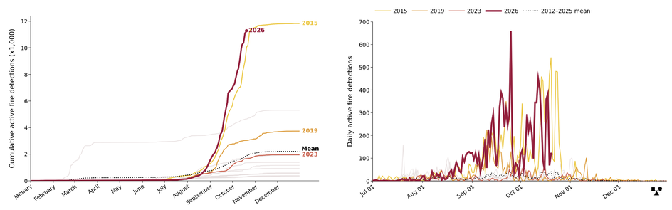
Figure 2. Cumulative (left) and daily (right) active-fire detections across areas now covered by 32 Indonesian forestry and peatland carbon projects, including observations predating project start dates. El Niño years are shown in colour, non-El Niño years in grey, and the long-term mean as a dashed black line. Data from BeZero's monitoring system, using daily NASA VIIRS (VNP14IMG and VJ114IMG) observations.
Rimba Raya Biodiversity Reserve Project (VCS674) and Katingan Peatland Restoration & Conservation Project (VCS1477), which began in 2008 and 2010 respectively, have experienced earlier surges in fire detections than in previous high-fire years (Figure 3a-b). At Katingan, detections have been numerous but concentrated near project boundaries, mostly in areas with relatively low forest cover. The project reports that its teams and community firefighters have been actively responding to nearby fires, using firebreaks, peat wetting and water infrastructure to help contain their spread.
Katingan is one of three Verra-registered forestry projects granted approval by Indonesia's Ministry of Forestry for carbon-unit issuance under its updated regulations in July 2026. Another, the Sumatra Merang Peatland Project (VCS1899), had recorded no active-fire detections in 2026 as of 20 October.
Our monitoring indicates elevated fire activity at 16 other projects, most of which have yet to issue credits. These include the Mayas Project (VCS3591), the third of the Verra projects approved by Indonesia's Ministry of Forestry, alongside the Kahayan Conservation Project (VCS4292) (Figure 3c-d), South Barito Kapuas Project (VCS4782) and Seram Climate & Conservation Project (VCS5283). All four show fire detections across several portions of their project areas. At most other affected projects, detections have been more localised, although fire activity could become more widespread if dry conditions persist.
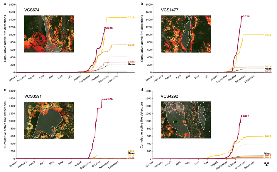
Figure 3. Examples of post-issuance (a–b) and pre-issuance (c–d) carbon projects with notable fire activity. Main charts show cumulative active-fire detections over time, with El Niño years in colour, non-El Niño years in grey, and the long-term mean as a dashed black line. Inset maps show the spatial distribution of detections, coloured by detection date (yellow to red, oldest to most recent), with project boundaries outlined in white. Fire data: NASA VIIRS (VNP14IMG and VJ114IMG), retrieved daily through BeZero's monitoring system. Background imagery: Planet Labs, July–September 2026.
These observations reinforce the importance of sustained forest protection, restoration and fire management, from established carbon projects such as Rimba Raya and Katingan to the many still in development or yet to issue credits. At Mayas, Kahayan, South Barito and Seram, these efforts include preventing forest conversion, halting commercial logging, restoring degraded peatlands, and supporting community fire prevention, monitoring and response.
Active-fire detections provide early warning of potential carbon impacts, but do not, on their own, establish the area burned, severity of damage or associated carbon losses. Assessing the implications for issued credits requires estimating any losses, evaluating whether project interventions have reduced impacts relative to the without-project baseline, and understanding how projects will account for those impacts.
From fire hotspots to carbon risk
Permanence risk from natural hazards depends on the likelihood of disturbances over a project's commitment period, their long-term impacts on carbon stocks, and how those risks or resulting emissions are mitigated or accounted for.
Historical burned-area records help establish where and how often wildfires occur. BeZero combines NASA burned-area products with near-real-time active-fire detections, which can reveal smaller or smouldering fires, including in peatlands. Our alerting system compares current detections with records dating back to 2012, flagging unusually early or elevated activity within rated projects for analyst review.
Our analysts assess potential carbon losses using burned-area, land-cover, carbon-stock and project-specific data. They estimate direct fire emissions and longer-term losses from tree mortality, drawing on satellite-derived carbon estimates, field measurements and published studies. For peatland projects, local soil and hydrological conditions are particularly important: waterlogged peat is relatively resistant to burning, whereas drainage can increase fire susceptibility and the risk of below-ground carbon losses.
Assessing implications for credit quality requires considering these impacts against a credible without-project baseline. Forest protection, peatland restoration and fire management may reduce emissions even where fires occur. Our analysts therefore consider the effectiveness of project interventions, alongside how any losses are accounted for.
Market-wide monitoring
Extending this monitoring across the carbon market requires reliable spatial information on project boundaries. These have historically been difficult to obtain, with data scattered across registries and project documents in inconsistent and sometimes undigitised formats.
BeZero maintains a harmonised, regularly updated geospatial database covering more than 3,000 nature-based projects across over 20 registries. Combined with satellite observations, this enables consistent monitoring of natural-hazard exposure across our rated portfolio and the wider market.
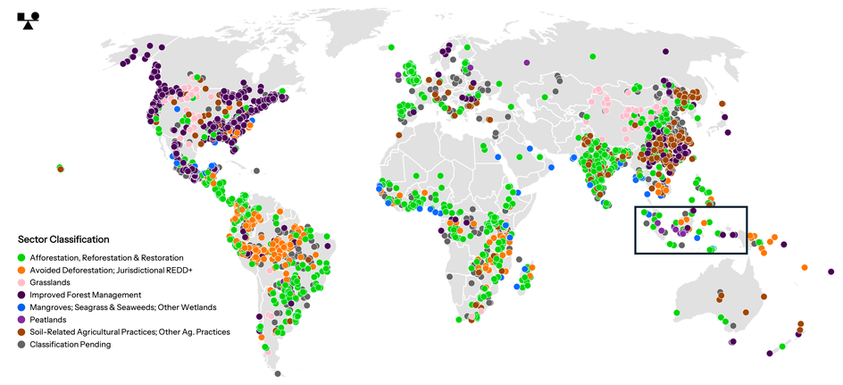
Figure 4. Global distribution of nature-based carbon projects in BeZero's geospatial database. Each dot represents a project centroid, coloured by sector classification. Precise boundaries are omitted for clarity at this scale. The outlined box highlights Indonesia.
This capability extends well beyond Indonesia (Figure 4). We will share further insights from our global monitoring in the forthcoming annual State of Wildfires update, due in the coming weeks.
What comes next?
The coming weeks will be important. Some rainfall is forecast across parts of Indonesia, with seasonal rainfall expected to increase in November. Sustained rains should help reduce fire risk, particularly on peatlands. Fire risks could subsequently intensify across other tropical regions in early 2027, although impacts will depend on local conditions.
For projects experiencing fire activity, we will continue monitoring detections and, as further satellite observations and project reports become available, assess the extent of burning, associated carbon losses and effectiveness of project interventions.
Fire risk is already factored into our ratings, but observed events provide new evidence of project exposure and the effectiveness of mitigation measures. Our analysts assess whether this could materially affect credit quality and warrant recommending that a rated credit vintage be placed on Ratings Watch pending further analysis. As of 22 October, no ratings actions have resulted from these fires. Any subsequent actions will be publicly communicated.
As El Niño's effects unfold across the tropics, sustained forest protection, restoration and fire management will remain important for reducing future risks. Carbon finance can help support these efforts, while independent ratings provide ongoing assessments of the likelihood that associated carbon credits deliver their claimed climate benefits.
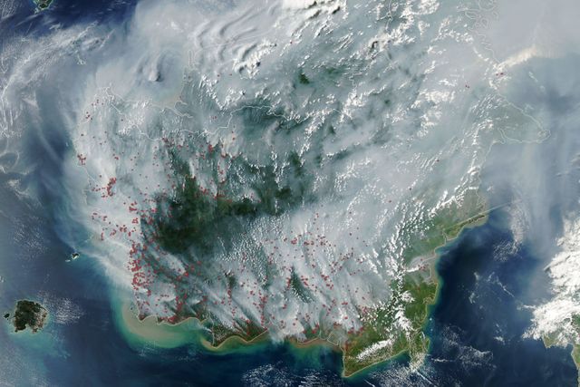
Cover image: NASA Earth Observatory / Lauren Dauphin.