BeZero Carbon partners with Chloris Geospatial to strengthen global forest carbon measurement
BeZero Carbon and Chloris Geospatial announce a partnership to advance biomass estimation across forestry projects globally.
BeZero gains access to Chloris’ satellite-based biomass data, whilst Chloris receives extensive global ground truth from BeZero’s plots database for model validation.
The collaboration strengthens BeZero’s multi-source geospatial capabilities, supporting its independent carbon ratings and deepening transparency across carbon markets.
Global carbon ratings agency BeZero Carbon today announces a partnership with Chloris Geospatial, a leading technology company measuring forest biomass from space. The partnership advances biomass estimation across forestry projects globally by expanding the data powering BeZero’s independent carbon ratings, alongside strengthening Chloris’ models through ground validation.
Under the partnership, BeZero will gain access to Chloris’ state-of-the-art forest biomass datasets. Chloris, which validates its models using airborne LiDAR and field data, will in turn access BeZero’s extensive global ground truth data to further strengthen its models. This will enhance both organisations’ analytical capabilities and reinforce the evidence base underpinning carbon project assessments.
The partnership forms part of BeZero’s multi-source geospatial strategy, which integrates the best available data from across the Earth observation ecosystem. BeZero draws upon more than 100 geospatial datasets to deliver independent, science-based analysis of carbon projects worldwide. The data complement BeZero’s collaboration with Planet Labs, announced in 2023, another leading provider of forest carbon data and operator of the world’s largest fleet of Earth-imaging satellites.
With the addition of Chloris’ biomass data, BeZero further extends the breadth and depth of its geospatial capabilities. Earlier this year, BeZero launched its nature-based carbon project boundaries dataset - the market’s first complete, global mapping of its kind. Together, these advances reinforce BeZero’s leadership in delivering rigorous geospatial analysis for carbon projects globally.
Dr Phil Platts, VP of Geospatial & Earth Observation at BeZero Carbon, said: “The team at Chloris bring decades of experience pioneering technologies for biomass mapping. Integrating their data in our geospatial systems will further strengthen our independent, project-level ratings and risk assessments.”
Dr Alessandro Baccini, Co-Founder, Co-CEO & Chief Science Officer at Chloris Geospatial, said: “BeZero’s global market influence, deep analytical capability and extensive ground truth make them an ideal partner. Together, we’re proud to advance transparent, scalable forest carbon measurement for organisations and markets working to accelerate climate action.”
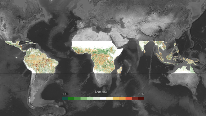
Cumulative change in pantropical aboveground biomass, 2000-2024. Chloris Data © 2025 Chloris Geospatial Inc.